- COMMUNITIES
- PUBLICATIONS
TMCnet Magazines
 Internet Telephony Magazine
Click here to read latest issue
Internet Telephony Magazine
Click here to read latest issue
Subscribe for FREE - Click Here CUSTOMER
Click here to read latest issue
Subscribe for FREE - Click Here Cloud Computing Magazine
Click here to read latest issue
Cloud Computing Magazine
Click here to read latest issue
Subscribe for FREE - Click Here IoT EVOLUTION MAGAZINE
Click here to read latest issue
Subscribe for FREE - Click Here - EVENTS
- AWARDS
- TECHNOLOGIES
TMCnet's Technology Sites
- MORE NEWS
Browse News by Topics
- BLOGS
- MORE
TMCnet Resources
About TMCnet
Subscriptions


|
March 2010 | Volume 2/Number 2
Feature Story
Exalt-Linked Video Surveillance Assists CAL FIRE in Wildland Fires
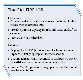
By Charlie Rubin With a mission to protect 31 million acres of privately-owned land in California, The California Department of Forestry and Fire Protection, better known as CAL FIRE, has a difficult job. The department provides emergency services response in 36 of the state’s 58 counties. And its resources include firefighters, fire engines and aircraft responding to an average “It’s not an ideal situation for us to only use information from 911 calls,” says Justin Sanders, battalion chief at CAL FIRE’s Amador/El Dorado Unit Emergency Command Center, “9-1-1 callers often do not know exactly where a fire is located.” As a result, CAL FIRE has had to dispatch aircraft to assist in determining the location, size and direction of fires. With such flights potentially costing thousands of dollars each, CAL FIRE decided to find a better, more cost-effective solution. The result is a system that uses high-definition video cameras mounted on unstaffed lookout towers. Two years in development, the system relies on microwave backhaul systems to connect the cameras with monitors and personnel at the ECC in Camino, Calif. The Exalt Solution Funded under a State of California grant, the video surveillance system in El Dorado County is the largest in the United States. The winning proposal was submitted by Vicom Wireless of Sacramento, Calif., which designed a system using Pelco Esprit HD video cameras featuring 35X zoom lenses with remote pan/tilt/zoom controls along with Exalt all-outdoor microwave radio systems that deliver video content over links ranging from 18 to 26 miles in length. The tower locations are at Big Hill, Pine Hill and Mount Danaher (News - Alert) , where the command center is located. Each radio system uses the 5.8GHz frequency band and is configured for 200mbps of aggregate Ethernet throughput. “We chose Exalt radios simply because they are, hands-down, the best radios on the market,” says Jim Cinquini, president of Vicom Wireless. “We knew they had the reliability to stand up to extreme weather conditions, and they are among the only radios that have built-in spectrum analyzers, which are incredibly valuable when setting up channels.” Another key advantage of the Exalt radios is that they offer throughput symmetry control, which allows users to adjust the amount of uplink and downlink capacity. “With a video application like this, most of the traffic is coming from the cameras,” says Cinquini. “We have the network configured so that 80 percent of the aggregate capacity is allocated to traffic from the cameras to the ECC.” The radios, switches and cameras on the lookout towers operate on 24 volt AC via power over Ethernet, and the cameras include built-in heaters to help protect them from the elements at elevations of 6,000 feet and higher. Better Information Means Better Response Since August 2009, the remote cameras have provided extremely precise information about the location of fires. Software on the monitoring workstation in the emergency command center can triangulate the azimuth and elevation figures from two different cameras to show a fire’s longitude and latitude, as well as the number of degrees above or below the horizon. By viewing this information on the workstation’s 52-inch monitor, the fire team can quickly evaluate how best to respond. Since its deployment, the surveillance system has worked great. “The camera system has become an important tool we can use to identify a fire’s location,” says Sanders. The Exalt microwave backhaul links have been completely reliable in all weather conditions, prompting CAL FIRE to plan for further expansion in 2010 and beyond. One additional camera and microwave link will be deployed atop Heavenly Valley in 2010, and the agency has an overall goal of eventually deploying as many as 22 cameras throughout Amador and El Dorado counties.
NGN Magazine Table of Contents |
 Facing drought conditions every summer, along with California budget issues that have reduced the number of staffed fire lookout towers, CAL FIRE needed to devise a system to allow for additional fire information because of the loss of staffed lookout towers. Exalt microwave backhaul systems have become part of a new solution that reduces costs and delivers more accurate information so CAL FIRE personnel can respond to wild land fires more quickly and efficiently.
